When the Map Fills Itself as You Go
Explore the innovative concept of dynamic map filling and its impact on navigation and exploration.
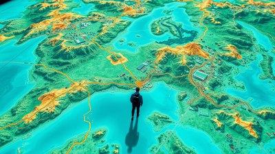
Image created with Flux Schnell
In an era where technology continually reshapes our interaction with the world, the idea of a map that fills itself as you go encapsulates a transformative approach to navigation and exploration. This concept not only revolutionizes how we understand geography but also provides a more immersive experience for explorers, adventurers, and everyday users alike. Imagine stepping into a new area, and as you traverse your surroundings, the map on your device dynamically updates, revealing pathways, landmarks, and even uncharted territories based on your movements. This concept stands as a fascinating intersection between geographic information systems (GIS), augmented reality (AR), and user-generated content, creating a vibrant tapestry of knowledge as we navigate through diverse environments.
The importance of maps in articulating space and direction cannot be overstated. For centuries, maps have served as navigational tools that aid travelers in locating destinations and understanding spatial relationships. However, traditional maps have limitations. They often represent static depictions of geography that can become obsolete as landscapes evolve or new developments arise. Enter the concept of dynamic mapping—an innovative way to address these challenges. With the advent of GPS technology and data visualization, it is now possible to create maps that adapt in real-time based on individual movements and collective input.
Dynamic maps operate on the principle of constantly updating data collected from various sources, including GPS signals, user interactions, and crowdsourced information. Every step a user takes in uncharted territory contributes to the larger community of travelers. As people navigate a city center, hike a trail, or wander through a rural area, the actions recorded can provide insights into pedestrian routes, scenic viewpoints, and even potential hazards. This evolving landscape of data allows for a richer, more detailed experience of navigation, allowing users to rely on a living document of their journeys.
The Role of Technology in Dynamic Mapping
The underlying technology behind dynamic mapping involves a synergy of several fields. Geographic Information Systems (GIS) provide the framework for mapping data while enabling analysis and visualization. Combined with advancements in mobile technology, individuals can interact with maps on portable devices, making real-time updates possible. Coupled with augmented reality, users can point their devices at their surroundings to receive instant information on landmarks, historical sites, and amenities based on their current position.
Furthermore, the integration of Artificial Intelligence (AI) and machine learning algorithms can analyze user data patterns, improving the accuracy of predictive mapping. As users explore and interact with their environment, the algorithms learn from their behavior, leading to better recommendations and more relevant information. This element of personalization enhances the user experience by providing a tailored map that reflects individual interests, whether they are looking for the fastest route to a destination or the most scenic path through a park.
Crowdsourcing and User-Generated Content
At the heart of dynamic mapping lies the concept of crowdsourcing, where contributions from ordinary users enhance the overall accuracy and richness of the map. As explorers traverse new territories, they can input data, such as new trails, restaurant reviews, or notable landmarks, which become part of the map's evolving structure. This real-time updating mechanism fosters a sense of community among users, as each participant becomes a contributor to a collective knowledge base.
In cities and populated areas, the power of user-generated content is particularly significant. Features such as user-generated waypoints, points of interest (POIs), and even user-submitted images can enrich the mapping experience. For instance, someone hiking a popular trail can share photos of beautiful vistas, while a traveler in an unfamiliar city can recommend particular cafes or shops based on personal experience. As new users join the mapping platform, they can immediately benefit from the collective input of previous explorers, turning each outing into a shared journey.
Applications in Different Fields
The applications of self-filling maps are virtually limitless, spanning across various fields including tourism, transportation, urban planning, and environmental conservation. In tourism, dynamic maps can enhance the experience of travelers by presenting real-time recommendations for activities, restaurants, and attractions based on current user interests and location. For transportation, this technology can optimize routes, reduce traffic congestion, and assist in navigation for public transit, all while adapting to real-time conditions.
Urban planners can also utilize dynamic mapping in designing infrastructure. The data collected from users can highlight which areas are highly trafficked, revealing patterns that inform better city planning and resource allocation. Environmental organizations can employ self-filling maps to monitor changes in landscape and biodiversity, helping them track invasive species or assess the impact of conservation efforts. In this way, technology serves as a critical asset in understanding and navigating our world with precision.
Challenges and Considerations
Despite the exciting potential of dynamic mapping, several challenges and considerations must be addressed as this technology becomes more ingrained in everyday navigation. Data privacy is paramount—users must be informed of how their location data is used, and measures should exist to safeguard sensitive information. Developers and organizations must prioritize transparent policies that allow users to control their data while participating in the mapping experience.
Additionally, misconceptions about the reliability of these maps can impact user trust. Since dynamic mappings often rely on crowd-sourced information, users may question the accuracy of certain entries. Continuous efforts to ensure data quality and implement verification processes are necessary to instill confidence among community participants, ensuring that dynamic maps remain a trustworthy resource for exploration.
The Future of Dynamic Mapping
The future of mapping technology is bright as advancements continue to shape user experiences. With the integration of Internet of Things (IoT) devices and smart sensors, the potential for real-time location tracking will enhance self-filling maps significantly. Picture a scenario where vehicles, smartphones, and smart city infrastructure communicate seamlessly to deliver comprehensive mapping data in real-time. This interconnected approach could reshape not only how we navigate but also how we interact with our environment, making exploration a richer and more meaningful experience.
Furthermore, as AR technology grows more sophisticated, the experience of dynamic mapping will only deepen. Imagine donning AR glasses that overlay digital mapping information onscreen while you explore a city or natural area. In this visualization, points of interest can materialize as you approach, offering insights and enriching the narrative of your journey as it literally unfolds before your eyes. Such experiences underscore the fusion of the digital and physical world, revolutionizing how individuals engage with their surroundings.
In conclusion, the concept of maps that fill themselves as you go represents a remarkable evolution in the way we navigate, explore, and interact with our landscapes. By harnessing the power of technology, user-generated data, and collective experiences, dynamic mapping allows users to participate actively in the storytelling of their journeys. As this technology continues to grow and evolve, we welcome an era of exploration that is not only informed by static maps but shaped through our adventures and shared experiences, ultimately creating a richer and more connected world. Whether you're an adventurer, a tourist, or simply a curious individual, the journey of discovering unfolds one step at a time, with the map evolving as you go.